
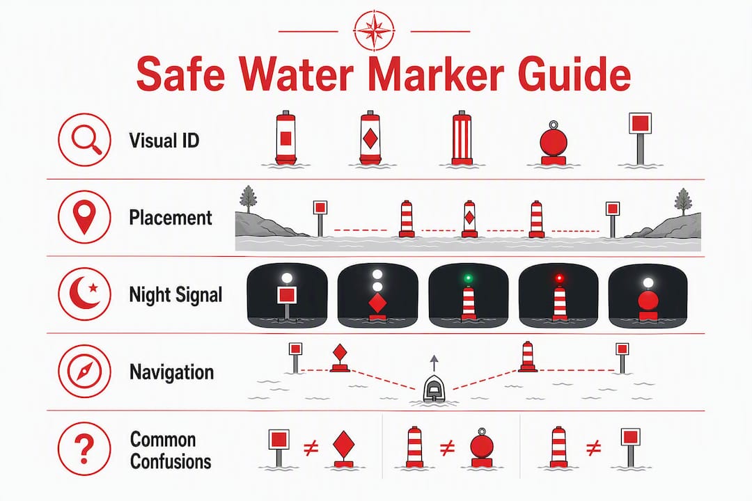
Safe Water Markers: Visual ID and Navigation Guide

A safe water marker means navigable water exists all around the mark. Under 33 CFR 62.27, these marks indicate fairways, midchannels, or the seaward ends of buoyed approaches — and seeing one calls for three immediate actions:
- Confirm the mark’s identity and position on your chart or GPS plotter before altering course.
- Maintain a safe, controlled speed and keep a proper lookout, especially in reduced visibility.
- Yield to any large commercial vessel navigating near the mark; they have limited maneuvering room.
Safeboatingamerica, a nationally recognized boating safety education provider, covers aids to navigation, chart reading, and collision avoidance in its NASBLA-approved courses — the same skills you need to act correctly the moment one of these marks comes into view.
Table of Contents
- What do safe water markers look like?
- Where are safe water markers placed, and what do they mean?
- How do you read safe water marker lights at night?
- What U.S. regulations govern safe water markers?
- How should you navigate when you see a safe water marker?
- Which marks are commonly confused with safe water markers?
- Why does formal boating education matter for reading aids to navigation?
- Key Takeaways
- Marks are aids, not guarantees
- Get structured training on buoyage and navigation
- Useful sources and where to check before you sail
- FAQ
What do safe water markers look like?
The definitive visual cue is alternating red and white vertical stripes. No other standard U.S. buoy type uses that color pattern, which makes it the fastest way to confirm what you’re looking at from a distance.
Shape varies by installation type. A floating buoy is spherical, pillar, or spar; a fixed beacon uses an octagonal daymark. When a topmark is fitted, it is always a single red sphere mounted at the top of the structure. The topmark matters most in cluttered anchorages or harbor approaches where multiple buoy types cluster together — the red ball on a striped body is an unambiguous ID at a glance.
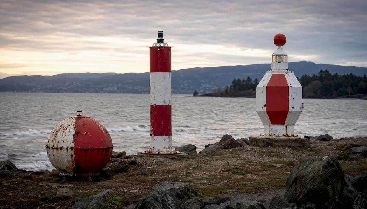
You may also hear these marks called fairway buoys, mid-channel buoys, or clear water buoys. Those names describe location or function, but the visual pattern — red and white vertical stripes, red spherical topmark — is the definitive identifier regardless of what anyone calls it locally.
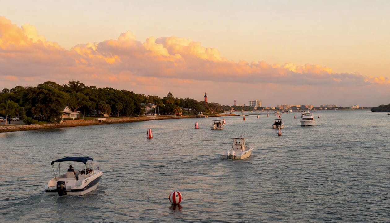
Pro Tip: If you’re uncertain whether a buoy is a safe water mark or a lateral mark, check the stripe direction. Lateral marks use horizontal bands or solid colors; safe water marks always run vertical stripes.
Where are safe water markers placed, and what do they mean?
These marks appear at predictable locations:
- Channel entrances: Positioned at the seaward end of a buoyed approach to indicate where a safe route begins.
- Mid-channel: Placed along the centerline of a fairway to confirm the navigable lane.
- Landfall approaches: Used offshore as the first mark a vessel encounters when making a coastal approach.
- Safe routes through shoals: A series of these marks can define a safe corridor through otherwise shallow water.
“Safe water all around” does not mean the area is free of every hazard. Shallow patches, submerged obstructions, and heavy commercial traffic can all exist near a safe water mark. IALA defines safe water marks as sea marks for maritime pilotage and recommends consulting charts for the specific meaning at each location. Cross-reference the letter or number printed on the buoy with your nautical chart before committing to a course.
How do you read safe water marker lights at night?
White is the standard light color for these marks. The pattern, not just the color, is what confirms the mark type after dark. Common characteristics include:
- Isophase white (Iso W): Equal periods of light and dark — steady, predictable rhythm.
- Occulting white (Oc W): Light is on longer than it is off; the mark appears to blink dark briefly.
- Long flash (LFl W): A single long white flash, typically every 10 seconds.
- Morse “A” (Mo(A) W): A short flash followed by a long flash — the di-dah pattern of the letter A in Morse code.
Morse “A” is the most distinctive of these characteristics. Experienced navigators use it at night to confirm they are approaching a safe water mark before committing to a channel entry. A white light alone does not change the mark’s meaning — it simply aids recognition in darkness. Always verify the exact characteristic against the NOAA Light List or your chart before departure, not from memory.
Pro Tip: Count the flash pattern aloud as you approach. Morse “A” is unmistakable once you hear yourself say “short — long.” That rhythm is your confirmation.
What U.S. regulations govern safe water markers?
33 CFR 62.27 is the controlling federal rule. Its core provision: safe water marks indicate that navigable water exists all around the mark and are used to mark fairways, midchannels, and the seaward ends of channels.
“Safe water marks are used to indicate that there is navigable water all around the mark. They may be used to mark fairways, mid-channels, or they may be used as landfall or approach buoys.” — 33 CFR 62.27
Three official publications govern mark characteristics and updates in U.S. waters:
- NOAA Nautical Charts: — The primary reference for mark positions, symbols, and associated depths.
Check the LNM for your district and confirm Light List entries before any unfamiliar voyage. If you encounter a mark that appears damaged, missing, or off-station, report it to the nearest USCG Sector or local marine authority immediately. Do not assume another vessel has already made the report.
How should you navigate when you see a safe water marker?
Sighting one of these marks calls for a specific sequence of actions, not just a course adjustment:
- Confirm on chart or GPS. Match the buoy’s printed letter or number to its charted position. That alphanumeric ID is a fast, reliable way to fix your position without guesswork.
- Assess traffic. Large commercial vessels frequently pass close to these marks. Yield and give way; do not assume they see you.
- Pass on either side. Unlike lateral marks, a safe water mark may be passed on any side when conditions allow. If the mark is serving as a centerline guide, combine its meaning with adjacent lateral marks to stay in the channel.
- Maintain safe speed. Reduced visibility, vessel traffic, and proximity to shoals all argue for slower speed near any aid to navigation.
- Report problems. If the buoy is off-station or shows damage, call USCG Sector on VHF Channel 16 or contact the local marine authority.
For close-quarters maneuvering near marks, safe boat mooring and docking techniques apply directly — controlled approach speed and early course corrections prevent incidents.
Pro Tip: When you spot a safe water mark, read its number first, then find it on the chart. That two-second habit gives you a confirmed position fix faster than any other method.
Which marks are commonly confused with safe water markers?
The table below covers the four mark types most often mistaken for each other.
| Mark type | Color pattern | Topmark | Typical use |
|---|---|---|---|
| Safe water | Red and white vertical stripes | Single red sphere | Fairway, mid-channel, landfall approach |
| Port lateral (U.S.) | Solid green | Single green cylinder | Left side of channel (returning from sea) |
| Starboard lateral (U.S.) | Solid red | Single red cone | Right side of channel (returning from sea) |
| Isolated danger | Black and red horizontal bands | Two black spheres | Marks a specific hazard with navigable water around it |
| Special mark | Yellow | Yellow X shape | Special purpose (anchorage, restricted area, etc.) |
The most common mix-up is between safe water marks and isolated danger marks. Both have red elements, but isolated danger marks use horizontal black and red bands and carry two black spheres as a topmark. The stripe direction and topmark count are the two fastest checks. When in doubt, consult the chart symbol rather than relying on color alone — chart symbols are unambiguous.
Why does formal boating education matter for reading aids to navigation?
Reading a buoy correctly in calm conditions is straightforward. Reading it correctly at night, in chop, with traffic around you, and while managing your vessel is a different skill set entirely. NASBLA-approved course materials, the standard used by state-approved programs across the U.S., cover chart cross-reference, light recognition, and collision avoidance around aids to navigation as integrated competencies, not isolated facts.
Official sources — the USCG, NOAA, and the Light List — are mandatory verification resources, not optional references. Formal boating safety education teaches boaters to use those publications as part of pre-departure routine, not just in emergencies.
- NASBLA-approved curricula include buoyage systems, chart reading, and Rules of the Road.
- State-approved courses satisfy certification requirements in every U.S. state.
- Safeboatingamerica offers online, live Zoom, and in-person formats taught by State Certified Instructors and USCG-Licensed Captains.
Understanding boat navigation methods and tools — including how to use a chart plotter alongside physical charts — is part of what separates a certified boater from one who is simply guessing.
Key Takeaways
A safe water marker indicates navigable water all around the mark under 33 CFR 62.27, but it does not guarantee the absence of hazards — always confirm position on a current chart before altering course.
| Point | Details |
|---|---|
| Visual ID | Red and white vertical stripes; red spherical topmark when fitted; may be spherical, pillar, or spar. |
| Passing rules | May be passed on either side; combine with lateral marks to stay in a defined channel. |
| Night signals | Look for Iso W, Oc W, LFl W, or Mo(A) W; Morse “A” (short-long) is the most distinctive pattern. |
| Chart verification | Match the buoy’s printed letter or number to its charted position; check the Light List and Local Notice to Mariners before departure. |
| Training resource | Safeboatingamerica’s NASBLA-approved courses cover buoyage, chart reading, and collision avoidance for certification in every U.S. state. |
Marks are aids, not guarantees
The phrase “safe water all around” is a navigational statement, not a promise. A safe water mark tells you the water is navigable in the vicinity of the mark at the time it was placed and charted. It says nothing about what has shifted since, what is approaching from the opposite direction, or how a large vessel behind you is reading the same channel.
The conservative practice is to treat every aid to navigation as a starting point for verification, not a conclusion. Check the chart. Check the Light List. Check the Local Notice to Mariners. Then navigate. Marks are tools; the judgment is yours.
Get structured training on buoyage and navigation
Knowing what a safe water mark looks like is one thing. Knowing how to use it, cross-reference it on a chart, read its light at night, and make the right call with traffic around you is what a structured course actually teaches.
Safeboatingamerica offers state-approved boating safety certification in every U.S. state, with online, live Zoom, and in-person formats. Courses are taught by State Certified Instructors and USCG-Licensed Captains using NASBLA-approved materials that cover buoyage systems, chart reading, Rules of the Road, and night navigation. Whether you need a New York boating safety certificate under Brianna’s Law, a Connecticut Safe Boating Certificate, or certification for any other state, the course format fits your schedule. Register for a boating safety course and leave the water with a certification and the skills to use it.
Useful sources and where to check before you sail
Verify mark characteristics and any temporary changes using these primary references before departure:
- 33 CFR 62.27 (eCFR): The federal regulation defining safe water marks and their required characteristics.
- NOAA Chart Services: Current nautical charts for U.S. waters; update before any unfamiliar voyage.
- IALA — About IALA: The international body that defines buoyage standards, including the IALA Maritime Buoyage System used in U.S. waters.
| Resource | What it covers | Update frequency |
|---|---|---|
| 33 CFR 62.27 | Federal definition and visual requirements | As amended |
| NOAA Nautical Charts | Mark positions, symbols, depths | Continuous (download current edition) |
| NOAA Light List | Light characteristics, positions, identifiers | Annual volumes; check LNM for interim changes |
| Local Notice to Mariners | Temporary changes, off-station marks | Weekly by USCG District |
| IALA R1001 | International buoyage standards | As published by IALA |
FAQ
What does a safe water marker indicate?
A safe water marker indicates that navigable water exists all around the mark, per 33 CFR 62.27. It does not confirm the absence of all hazards — always cross-reference with a current nautical chart.
What does a safe water mark look like?
It displays alternating red and white vertical stripes and, when fitted, a single red spherical topmark. The buoy shape may be spherical, pillar, or spar; fixed beacons use an octagonal daymark.
What is the topmark on a safe water mark?
The topmark is a single red sphere. Its presence on a striped buoy is the fastest visual confirmation that the mark is a safe water mark rather than any other buoy type.
What is a safe water channel marker?
A safe water channel marker is a fairway or mid-channel buoy that defines the navigable centerline of a channel or the seaward start of a buoyed approach. It may be passed on either side, unlike lateral marks that must be kept to a specific side.
How do you identify a safe water mark at night?
Look for a white light showing Isophase (Iso W), Occulting (Oc W), Long Flash (LFl W), or Morse “A” (Mo(A) W). The Morse “A” pattern — one short flash followed by one long flash — is the most distinctive and is confirmed against the NOAA Light List for your area.